
https://land.copernicus.eu/pan-european ... u-dem-v1.1" target="_blank
Ich zitiere die Webseite:
Klingt für Gebiete vielversprechend, die nicht durch hochauflösendere Angebote abgedeckt sind, und so habe ich mal versucht, einen Teil von Island (sehr kleine Datenmenge) einzulesen, leider ohne Erfolg:EU-DEM v1.0 is a digital surface model (DSM) of EEA39 countries representing the first surface as illuminated by the sensors. It is a hybrid product based on SRTM and ASTER GDEM data fused by a weighted averaging approach. The statistical validation of EU-DEM v1.0 documents a relatively unbiased (-0.56 meters) overall vertical accuracy of 2.9 meters RMSE, which is fully within the contractual specification of 7m RMSE (European Commission 2009). Please read the full report here.
The following corrections and improvements have been implemented in EU-DEM v1.1:
systematic correction of geo-positioning issues (found and corrected for Malta and Lampedusa islands);
bias adjustment with ICESat;
screening and removal of artefacts, including the presence of blunders (i.e. negative or positive anomalies); more than 75.000 artefacts have been detected and corrected;
consistency with the upgraded version of EU-Hydro, in order to produce a better river network topology.
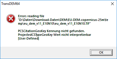

Das TIF ist zwar anwählbar, aber sowohl mit der Version 1.1 als auch der älteren Version 1.0 klappt es nicht. Liegt es an den folgenden Projektionsparametern:
The x,y-coordinates in the tiles are based on the EPSG:3035 (ETRS89-LAEA) projection.
